
Vancouver has two types of hikers. There are those who put on Crocs and wander around a lake on a path that might as well be paved, go up a flight of stairs, pat their fat old dog, and say “that was a good hike.” Then there are the people who voyage into places shown on the map only as “Bad Idea,” dropping sentences like “after a brisk fourteen miles through waist-deep poison ivy I ascended the cliff to Mount Hopeless and ate an entire box of After Eights.” The first group writes tour guides and fills up buses, the second group writes trip reports and fills up message boards. Damn the lot of ’em.
What about us normies? Those who don’t mind being sore the next morning but react to the word “bushwhack” like the fat old dog to “vet”? Our stories are lost, not impressive enough for the survivorman and too try-hard to the weekend stroller.
Today I defy convention. On a sunny Sunday in July I took my first shot at Coliseum Mountain, in Lynn Headwaters Regional Park on Vancouver’s North Shore. Lynn Headwaters is one of my favourite places in the world. It has trails for all: ones you can wheelchair down, ones with a bit of a climb, ones which tax all but the very fit, and routes with mountain traverses and alpine challenges that the park would not dare to advertise, for fear of great reeking heaps of dead tourists. If you like company, head into Lynn Canyon and get booty-shorts tight with people taking iPad selfies on a suspension bridge that’s more biomass than structure. If you like solitude, Lynn Headwaters can provide even on weekend afternoons. It is a little patch of joy.
Coliseum Mountain is, with the justly-famous Hanes Valley trail and justly-ignored Lynn Lake, one of three hikes the park calls very difficult. You can seek out tougher routes in the deep backcountry but for a tubby guy in 27-degree weather with a heavy pack full of crackers Coliseum is certainly tough enough to be getting on with. It is a long way horizontally and vertically: more of both than I had ever hiked in a day before. Is it worth it?
Oh heavens yes.
As always, all statistics are from my Garmin fēnix 3 GPS watch, and GPS heights in particular are notoriously inaccurate: the official height of Coliseum Mountain is 1446m. Also note that I got off the bus and these statistics therefore include a return trip on the very easy 1.8-mile Varley Trail, providing access from the bus stop to Lynn Headwaters Park proper.
For most of us, ascending nearly a vertical mile and hiking 18 of the horizontal ones is a good day’s work, but it does conjure up a long but steady grade to the top of a mountain and then back. On Coliseum, the figures lie. More than half of the horizontal distance is along the lower Lynn Loop, Cedar Mill, and Norvan Falls trails. The lower Lynn Loop is wheelchair-accessible, the Cedar Mill trail is very easy, and the Norvan trail is a fairly courteous “moderate” that runs a healthy distance and makes you dart in and out of debris chutes now and again, but is nothing exotic. Norvan by itself is a good half-day trip with almost ten miles of trail, return, and 400 feet in cumulative elevation, and highly recommended. But it is emphatically the easy part of Coliseum.
Here is what happens. You walk almost to Norvan Falls, whistling and listening to podcasts. You pass people in swimming trunks, towels slung nonchalantly over their shoulders. You pass hordes of trail runners, because if you have any brains rattling around your skull you got out early and trail runners are strange creatures of the dawn. When you are in earshot of the falls, roaring their promise of scenery, water, and rest, you turn right at a sign that says “Coliseum Mountain Route” and, more ominously since you’ve just gone nearly five miles in an hour and a half, “allow 7 hrs.”
They’re not kidding. The first steps are over soft fir needles, following a route that isn’t a trail as such but is still so clearly marked that if you have any business even attempting this you’ll never get lost. While it’s harder than Norvan, you don’t see what all the fuss is about. But soon you’re scrambling up a set of long, steep, dirt hills, with footholds limited to narrow tree roots and, in dry conditions, the earth slipping away under your feet. There are two long inclines accounting for something like a thousand-foot climb in no time at all. I like to call these hills “the Gatekeepers,” because if you’re blown out by them, or terrified at the thought of the treacherous descent back down, then you should turn around and go back to the Norvan Falls and try again another day. The falls are lovely. You will be much happier.
Sometimes there are switchbacks but mostly you’re driving straight up, espying a route through the sweat, looking up for trail markers when you should be looking down. It’s actually not difficult, as the trail maintainers have put up so many yellow markers and so many miles of orange flagging tape that it is very friendly navigation. But you have to be paying that attention! You cannot be lost in the effort required to keep moving forward, you cannot reflexively dart for the path of least resistance because that will often be wrong. You need some mental reserves, beyond what it takes to just do the walking.
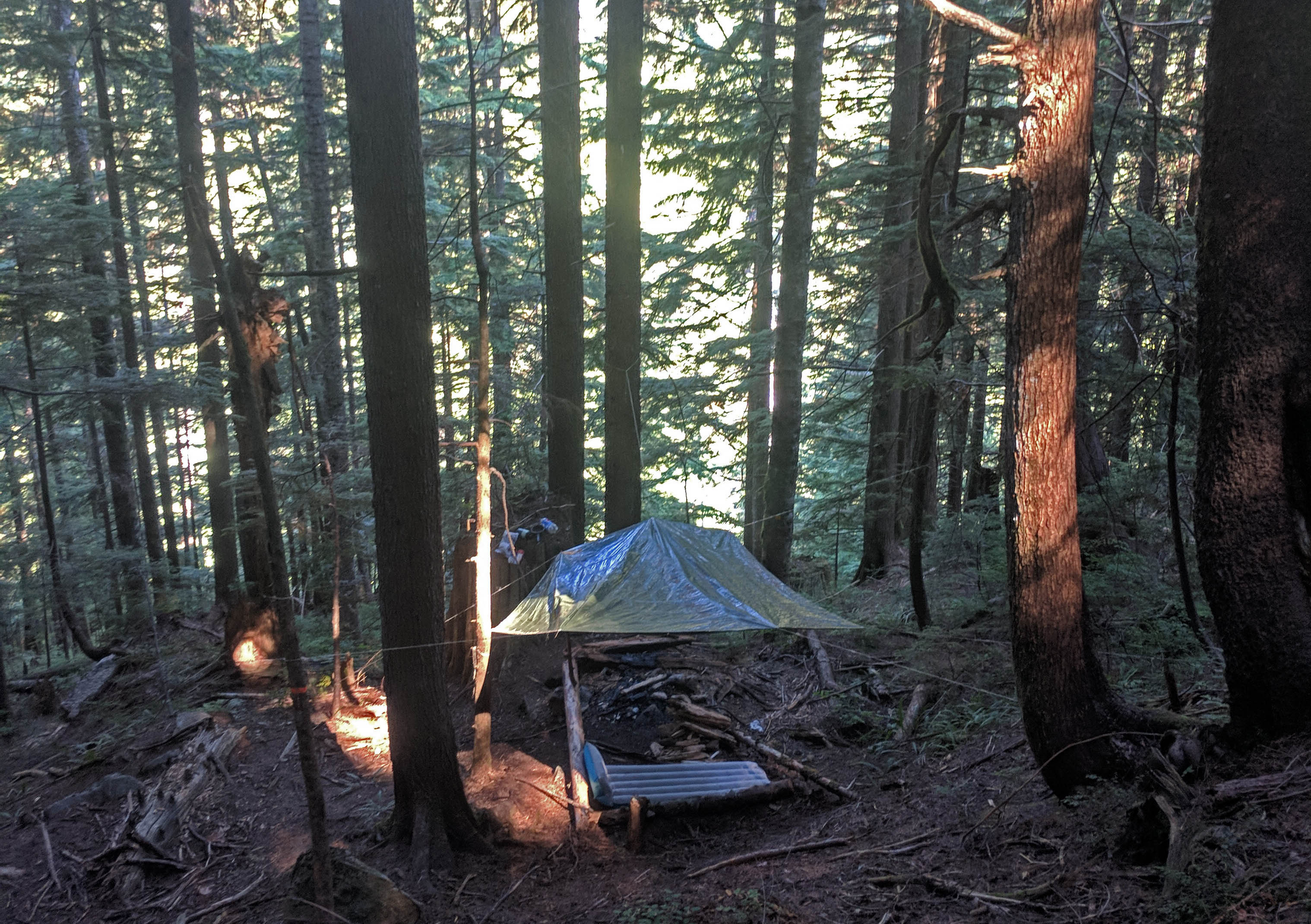
It’s a tough aerobic test. Indeed, for those looking to explore not only Coliseum but the mountains beyond, it must be tempting to trek part of the way and set up camp. Sadly overnight stays are strictly forbidden in all parts of Lynn Headwaters Regional Park. At around 10 AM on a Sunday morning I passed a couple of groups with heavy backpacks and sleeping pads returning from the Coliseum summit, but they were probably just 3 AM hikers testing themselves with heavy loads. I also saw what sure looked like a lightweight campsite right off the route and near enough to Norvan Falls that it’s very easy to find, but no doubt that was an optical illusion. Again, camping strictly forbidden and you would never do anything forbidden, would you?
The ascent is almost continuous but there is a moment of relative calm once you pass the Gatekeepers and enter the near-flatlands around Norvan Creek. You’re still moving up, and there’s plenty of mud and tree underfoot, but the grade is level enough that some good Samaritans have even placed steps in the worst mud bogs. It’s almost a trail here, but a rough one: there are huge fallen trees requiring careful detours that will probably never be removed, plenty of mud, plenty of stone and roots, and you will start to crave five ordinary strides like a starving man craves pepperoni. There are several rocky creeks and debris chutes that were all but dry at the end of July 2018, but probably flow like mad during the spring. These afford some fabulous views of the surrounding mountains as you ascend, and offer one of the Coliseum Mountain route’s most underrated assets: definite proof of progress. It is a tough trail but it loves you, it is the teacher who marks you down because he knows you will do better next time.
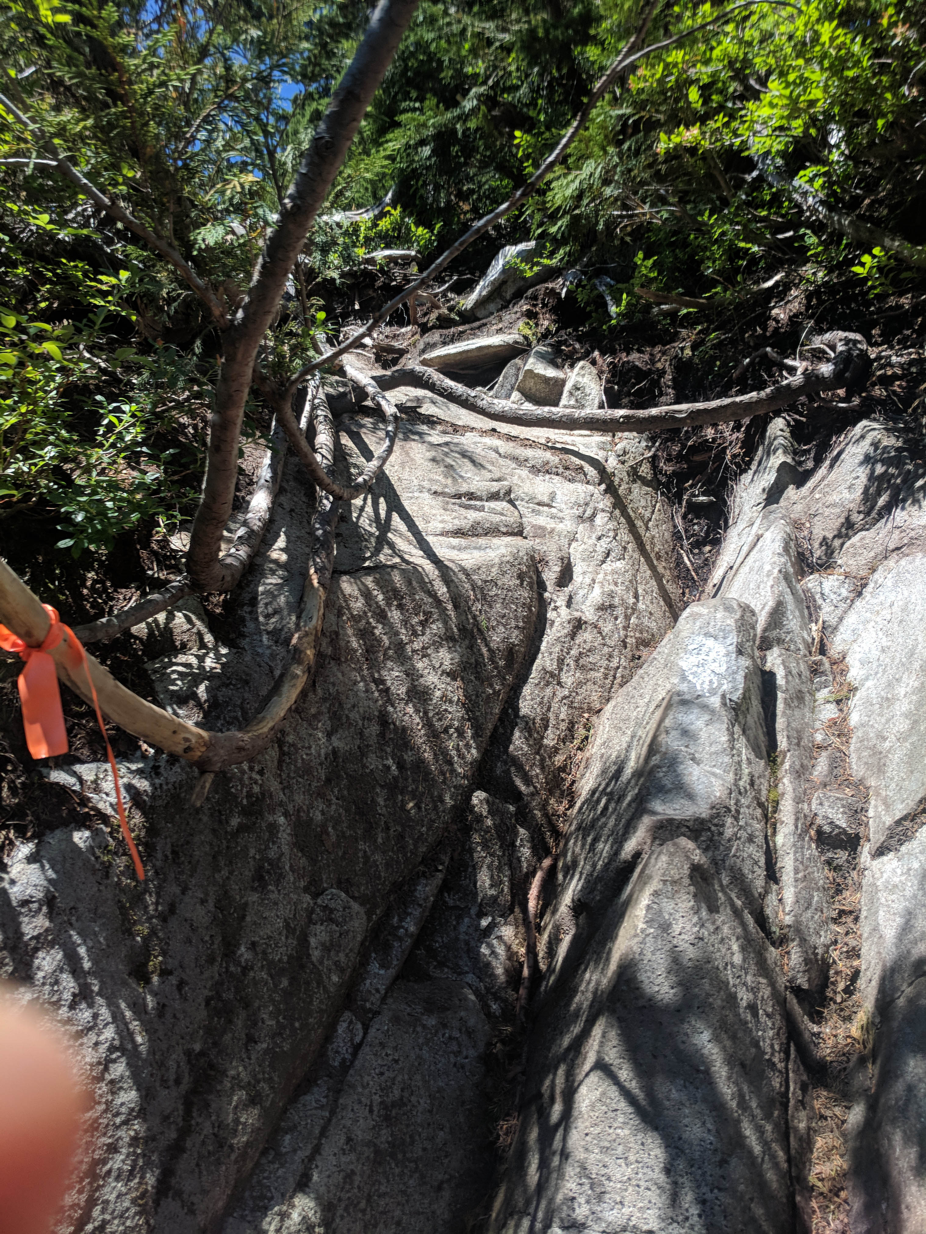
Keep going, up and up. You will cross Norvan Creek several times, and while one of my guides made great hay of this crossing I did not realize I’d done it except in hindsight, so don’t expect refreshing rushing water. Norvan Creek relies entirely on mountain runoff, and if you’re short on water you should stock up at the first opportunity1. At the meadow’s end, the steep dirt climbs will turn into steep rock climbs. Most of this only takes care and patience; there is one stone face that truly deserves to be called a “scramble” but nothing is tall enough that you can’t plan your steps in advance from the bottom. There are hand- and footholds enough for even clumsy tubbos to survive.
As an aside, that one scrambling face is also annoying on the way back, not only because you’re descending sheer stone but because it’s a slightly counter-intuitive left turn off a route that seems to offer another decent straight ahead. I hate to repeat myself but always look for the flagging tape, my friends.
Over time, the scenery will turn distinctly subalpine. One obvious intersection in the trail goes left towards the mountain and right towards a gorgeous viewpoint of the Mount Seymour system that you will be able to espy through the brush. Turn off and enjoy a moment of nature, relieve or nourish yourself as appropriate, and catch your breath. You are approximately a mile from the top of Coliseum Mountain, and that mile must be earned.
Turn left and pull your way up the rocks. This is the “steep scrambling section” the Lynn Headwaters map boasts of; short, but sweet. You will find nothing too severe if you’ve gotten this far but it’s still work, work, and work, more energy being debited from your account. In late July there were still patches of snow and a variety of moderately deep pools from which you could filter drinking water, but of course nothing of the sort can be counted on late in a hot season. The latest truly guaranteed water is at Norvan Falls.
In the alpine you follow bits of flagging tape up paths and cliffs, past cairns and wrong turns, heading up to Coliseum. There is one notable false summit along the way and another you might unwitting ascend if you miss the route. There are all sorts of paths to get you safely up Coliseum, and all sorts of others that might put you on the bad end of an obstacle or in a North Shore Rescue helicopter. However tired you are, slow down and use your judgement.
The good news is that, for all its ruggedness, this is a popular trail. I saw a dozen or so hikers go by on my summer Sunday, mostly well-prepared, fit, confident, and happy to shoot the breeze. Some people run this route, proving the Vancouver adage that there is no trail so tough that, at the very moment you’re feeling good about yourself for hiking it, somebody won’t come jogging past. As a result not only is the route well-marked but it’s regularly trafficked, which gives you much more than a fighting chance to successfully get up even if you’re unfamiliar with the area.
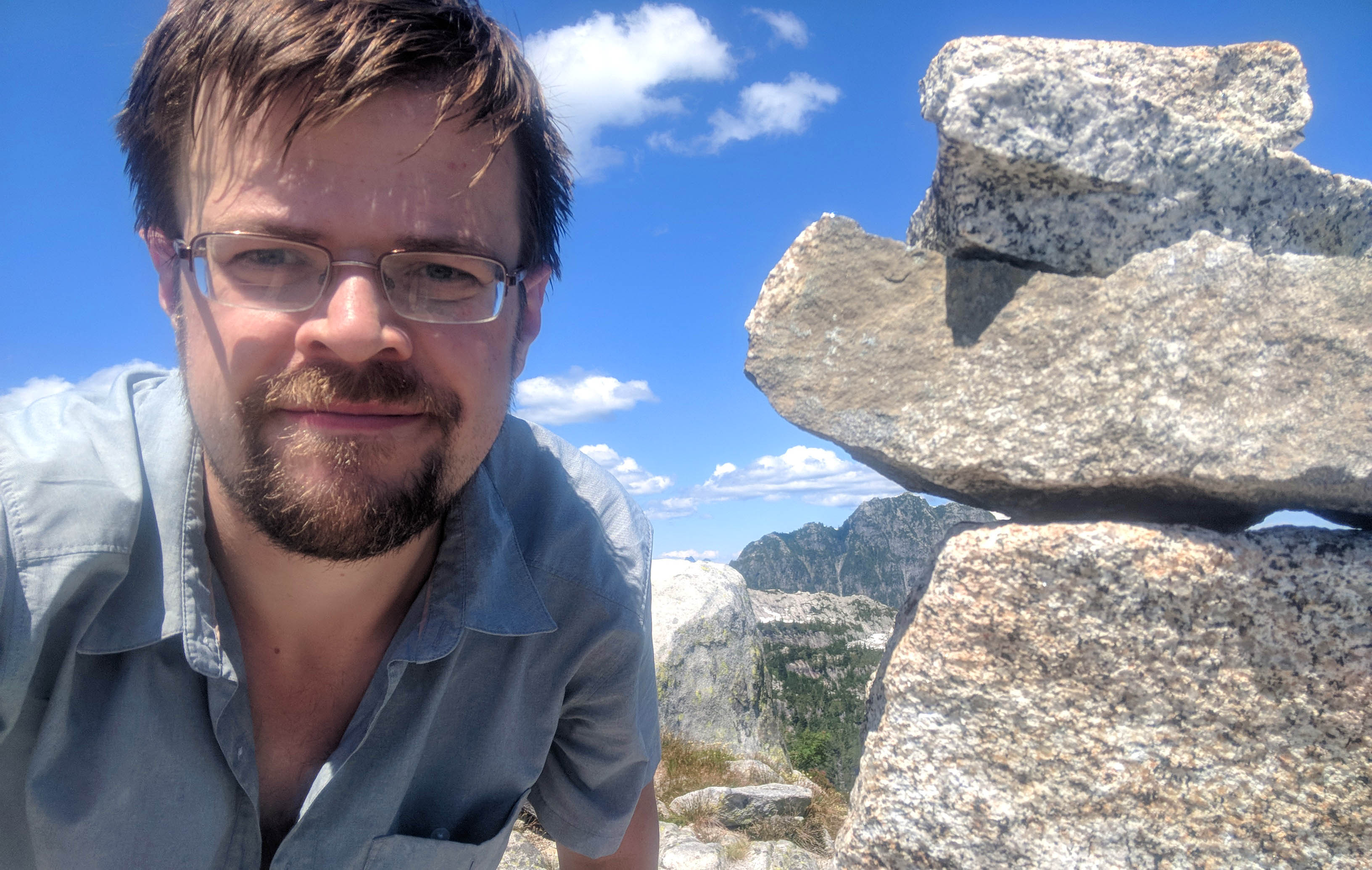
The better news is that the true summit of Coliseum is visible from a distance thanks to the generously-heaped cairn easily seen from the standard route. You will already be surrounded by great natural beauty and now you will be motivated, while after the false summit the last steps are as easy as they’ve been for some time. Then you arrive, and it’s beautiful. Every point of the compass yields itself to your eye. To the south, your vision follows the Needles and Lynn Peak back the way you came. To the west, the windmill of Grouse Mountain Resort provides an obvious landmark as you check out Goat, Dam, and Crown Mountains as well as the tricky boulder field of the Hanes Valley. North, the fabulous traverse to Mount Burwell, which looks almost easy to reach but is a mountaineering route for experts, and the solar-powered radio repeaters on distant and forbidden Cathedral Mountain, a watershed peak closed to all visitors. The summit area is broad and easy to travel, meaning that even on a busy day you can find a private spot to sit and admire the world. It is paradise on Earth.
But there’s bad news: what goes up must come down.
All in, from the Varley Trail onward, I got up Coliseum Mountain in about four and a half hours. Getting back down took me five. There is no gondola here. You have to walk back the way you came, all the views have been viewed, and it’s so steep. Such descents are often tougher than the ascents, when you factor in how tired you already are, and slipping down loose slopes with boots covered in mud got so frustrating so fast that I took many more breaks descending than I did going up. By the end, as I practically tiptoed down the Gatekeepers desperately begging the Norvan trail to come into view, I was ten times more fed up and tired than I had been when I got at top of the mountain2. You can hear the Norvan Falls deceptively far away, the barks of ill-trained dogs and the dumb shouts of degenerates crapping in the water fill your ears, but you’re still side-footing down dirt and pine needles and you’re tired and it just takes so long that even when you’re back on the Norvan Trail, back on Easy Street, you’re exhausted and mentally numb and you don’t make anything like the pace you ought to. The long, dull Headwaters Trail is best taken at speed, and the speed’s just not there anymore, and can you stop hiking? No, not yet.
Still, when you’re back at home, sore, ready to sleep for about fourteen hours, will you be thinking about how even three miles of dead-flat road felt like a lot of work, or will you be thinking about the vast mountainous vistas you’ve experienced and might experience again? If it’s the former I doubt you read this far.
- Especially in late season some of the water can come from old snow-melt ponds that can be a bit, um, lived-in, so a filter is better than UV or chemical treatment to make the water pleasant.
- I also developed a fabulous pair of blisters on my, um, lower back, when I slipped, dirt got down my underwear, and it combined with the sweat to scrape my skin raw for the rest of the trip.

