Ben Massey. Backpacking enthusiast, creator of this site, former writer of sports articles for several websites and one magazine, all-round handsome guy, and writer of his own blurbs.

Of Canada’s government-created problems, the poor state of some backcountry trails is not a major one. It affects thousands of people rather than millions and ruins vacations rather than livelihoods, safety, and society. Getting outside is good for you, physically, intellectually, and spiritually, so there are real consequences, but not quite as bad as the day-to-day Canadian experiences of unemployment, wage stagnation, price increases, and societal collapse. Hiking is not, in any properly-calibrated order, a very big deal.
However, it’s an interesting one. Parks Canada might be the electorally safest part of our government. There are institutions like the CBC or VIA Rail which defenders call underfunded and critics want abolished; their are quangos like the Canadian Forces or health care which everybody promises to improve and nobody does. But Parks Canada, though certainly criticized, is as close to a universal National Good Thing as we get. Nearly everyone wants Parks Canada around. The Libertarians would sell it, but they’re the only ones. Even the separatists object to the “Canada” part, not the “Parks.”
Yet it is clearly going downhill. Nearly everyone seems to want protected wild places that Canadians can access, except sometimes those responsible for providing it.
There are many types of government malice, using “government” in the proper, wider sense. The judges who write our most important laws, the bureaucrats by whose whim anything ever happens, the array of cultural and financial interests whose power would be so much simpler to deal with if it was all or even primarily about money.
You would hope that Parks Canada exists to do the best it can. Resources are finite, it has to prioritize, and sometimes priorities to you and me are not priorities to the nation; that is unfortunate, but healthy. Nonetheless, while Parks Canada’s dollar stretches only so far, we suppose it wants to do its best with every dollar it has, and taken all in all the organization will want the best for the country.
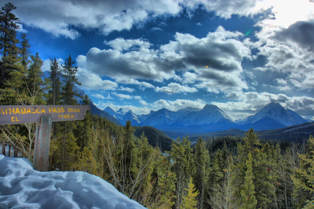
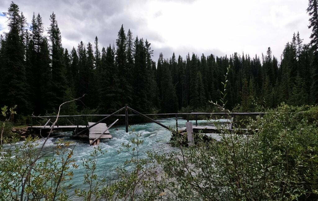
Friend reader, the example of the Simon Creek bridge to Athabasca Pass in Jasper National Park shows it is not so.
Never miss a ramble
Ben will hike to your inbox! New posts and nothing else.
- NORTH BOUNDARY—185 km. Elev. gain 1055 m. Max. elev. 2019 m. Trailheads are at Celestine Lake parking lot (limited access). 53 km from Jasper townsite, and at Mount Robson service area, 88 km west on Highway 16. The trail is well marked and all major river crossings are bridged. A variety of side trips are possible. Some horse traffic.—Jasper National Park trail information summary, 1985
North Boundary 179 km. Elevation gain: 2688 m and loss: 3122 m, from Celestine Road to Berg Lake trailhead. Maximum elevation: 2019 m. North Boundary country possesses its own unique brand of beauty – a wilderness of broad valleys and distant views that is inhabited by an array of wildlife. The trail is rugged in places although most major river crossings are bridged. Some horse traffic. Very remote, trail is maintained infrequently.—Jasper National Park backcountry guide, 2012
The North Boundary Trail
159 km one way | 7-10 days | Dogs permitted | Horses permitted | No bikes
The North Boundary trail is a remote wilderness route, recommended for users with significant backcountry skills and experience. Highlights include Snake Indian Pass and the headwaters of two major park rivers; the Snake Indian River and the Smoky River. Some major rivers are not bridged. Fords can be dangerous. Rivers can be impassable during times of high water. This trail is best travelled in later season.—Jasper National Park backcountry trip ideas guide, March 2025
How do trails get worse? Money. Bridges go out, tracks slide away and are never replaced, trees fall that are never cut, brush grows and hides the path away. Jasper’s backcountry trails are getting worse. But what does that mean?
Jasper National Park’s backcountry has never been more popular, and never harder to enjoy.
Backcountry trails in the park were at their height in the 1980s and 1990s. Usage was relatively low compared to the decades both before and since, but the trail network was over a third larger and generally in better shape. There was literally a hundred bridges, and it is said, perhaps exaggeratedly, that you could hike a hundred miles without getting your feet wet. Trails now considered adventurous low-water-season hikes were in regular use all summer, and the backcountry camper could have as much, or at little, privacy and challenge as he wanted.
Although Parks Canada hems, haws, and chooses their data carefully when the subject comes up, the fact is that more people than ever are using fewer backcountry trails. To be sure, backcountry campers are by-and-large white and by-and-large spend little money in town except at the bar, so are unfashionable visitors, but we are in an unprecedented boom of backcountry popularity which the park is content to treat with, at best, benign neglect.
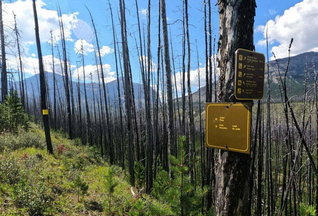
Parks Canada today documents about 775km of trails relevant to the backcountry hiker. This is the largest Jasper’s official backcountry trail network has been in over a decade, because the 47.7km Maligne Pass trail was formally re-opened, not that it helps any. Apart from Skyline, those kilometers are less accessible to horse and hiker than they were before. The Tonquin Valley has been closed to horses and lost its lodges and even the Brazeau Loop, one of the few trails Jasper cares about, has been for serious hikers only since a bridge went out in 2022.
What does this really mean? A couple of wonderful projects, the Parks Canada History Archive and the Canadian Backcountry Trails Preservation Society, have archived what Jasper National Park’s backcountry used to look like. It’s gotten a lot worse. Everyone who’s been there knows that. But it’s also gotten a lot smaller.
Unless otherwise noted, all content copyright 2016—2026 Benjamin Massey. All rights reserved. Any icons or trademarks used are the sole property of their respective companies. Powered by Wordpress.