


Hiking Jasper National Park’s North Boundary Trail has always called for thought. Even in the good old days, when dozens of bridges let hundreds of hikers enjoy the trail all summer and fall, it was still a hundred miles long and few would hike it in less than a week. Today, it has a very short season and some dangerous fords. Once upon a time it could easily be somebody’s first long backpack, with an appealing combination of remoteness and ease: isolated but otherwise unchallenging with well-kept campsites, good trail, few technical aspects, and plenty of predictability. No longer.
The trail’s been deteriorating for decades and in 2021, flooding on the western half of the trail took out two of the three most important remaining bridges, over Twintree and Chown Creeks, plus the entire Berg Lake Trail. Some people have done the trail since, often on horseback, but it’s become both more difficult and more obscure. All the YouTube videos are now somewhat out of date and the Twintree ford in particular has probably been taken on foot by fewer than twenty people, of whom I am now one.
Naturally, I put a good deal of planning into this trail, and (not least thanks to God providing some spectacular weather) it worked. I have experience, but not much fitness, and it proves the North Boundary Trail remains possible for the hiker, but you need to know what you’re getting into. Here is how I arranged my own hike.
Most public reports on the North Boundary Trail are, on account of the 2021 flooding, now somewhat out-of-date. There is still a great deal of value in the most recent YouTube videos of the complete hike, Stuart Howe and Bryan DeLay (who went together) and Marc of the Trail (separately) in 20191. The Canadian Rockies Trail Guide has been updated since then, but mostly to tell you things you already knew: the Berg Lake Trail was closed, and the bridges are out. “Though both [Twintree and Chown] creeks may be fordable late in the season, we cannot recommend travel west of Twintree Lake at this time,” they say. Neither do I, now that I’ve done it, but you have to admit it’s not helpful detail.
The popular Great Divide Trail crosses Chown Creek near the old bridge site (essentially the only part of the main GDT that follows the North Boundary Trail); they consider it fordable in normal conditions, but Twintree is undoubtedly trouble. Parks Canada has been in there on horseback, flagging a ford upstream of the old bridge site where the creek is broken into two channels by a small island. However, they cross it on horseback, and horses can handle much deeper water than humans. There was a good deal of uncertainty about that ford, it was the key point of the trail, and I consulted a guide (Ben Nearingburg of Starry Summit Mountain Adventures) who informed me that the ford was possible, he’d done it, and Parks Canada had cleared trail to the ford. This gave me the confidence to go on, though in the event I found the Twintree ford mid-thigh and swift at its worst, and felt blessed to get across with fear but without drama in the first week of September after seven bone-dry days. After I got back I read of another pair of hikers who had attempted the ford, and one had been swept off his feet but rescued by his partner: it is possible, but a properly dangerous short piece of work. None of the other fords, including Chown, were bad.
Bearing those water issues in mind, there are a few questions one must answer to hike the North Boundary. It’s not that complicated a hike, but it’s more complicated than most2.
-
When to go? This is the easiest question to answer. It is rare for a campsite on the North Boundary to ever be totally booked up, so in that sense, go when you like. The North Boundary is closed by Jasper National Park from November 1 to May 15, so winter is out. The major factors are weather and water levels. Because of the hazardous creek crossings, you want the lowest water levels that you possibly arrange, and the later in the season, the lower the water. The relative low altitude of most of the North Boundary means that snow is less of a risk than other trails, but its remoteness and lack of markers means that a modest fall that covers the trail could spell disaster, so you have to balance that. Even apart from snow, the later months are colder and with all the river fording and the probability of rain, hypothermia bears respect. The average adventurer, then, should not push the season out too far.
So the best month is September, when temperatures tend to be above freezing but there’s less water in the creeks. The government doesn’t measure water levels on most of the North Boundary streams, but in an ordinary year water level go right down around the last week of August and first week of September. The weather at that time ought to be good enough, though there’s always risk, and it’s probably the best you can do. You do not want to go in July unless you are on a horse.
-
Where to go? There are two practical eastern trailheads for the North Boundary Trail: the “traditional” start at Celestine Lake in Jasper, and the more common, but more remote, start at Rock Lake Provincial Park in Alberta. There are no buses, cheap taxis, or convenient shuttles to either spot, but Celestine Lake is slightly less inconvenient; for a three-digit sum of money you could get a cab and there’s a fair chance of finding a ride from a friendly local. It is, however, a 43-mile trudge on an old fire road to Willow Creek; not an unrewarding one, with some beautiful camping and the glorious Snake Indian Falls, but obnoxious. Most people start from the east (Rock Lake or Celestine Lake), not the west (Berg Lake) because that saves a good deal of very strenuous climb on the toughest first days of the trip when your pack is at its heaviest and your legs at their flabbiest, because it saves by far the best scenery for last, and because if your schedule goes a bit funny, it’s easier to improvise transport from the popular Mount Robson than the more obscure Rock or Celestine Lakes.
This is purely a question of taste. Most people who can start at Rock Lake do so, but there is no right answer.
Virtually every North Boundary Trail hiker then ends by hiking the Berg Lake Trail down to the Mount Robson Visitor Centre. This is, again, not the only option: the Moose River trail is much more remote but is used, and the Miette River trail still more-or-less exists if you’re hardcore. Any of them will get you to the Yellowhead Highway. For a first-timer Berg Lake is really the only choice; it almost requires a very long day (more on that later) but if you have never seen it before is well worthwhile. The great advantage of Moose River is that you can camp on it, so you can have a more flexible pace, and it’s not exactly ugly, but it’s longer, in rougher shape, and drops you in a less convenient spot. The great advantage of Miette River is that you probably won’t see anybody.
-
How long to take? It was once perfectly reasonable to hike the North Boundary in a week or even a bit less; the Parks Canada sign at the top of Robson Pass still says seven days from there to Rock Lake. The days are only medium-long and there is little climb. However, with so many creeks to ford, it is wise to give yourself some slack. Even at the best time of year, a rainstorm can make a major crossing impossible for a day or two, and some degree of flexibility is essential to a wisely-planned trip. Luckily, satellite weather forecasts make this sort of improvisation in the field much easier: not that they’re anything like completely accurate, but they suffice to give you the shape of the weather, to know that bad storms are coming (or, hopefully, aren’t).
Therefore, I took ten days over the end of August/beginning of September from Rock Lake to Mount Robson.
| North Boundary Trail 2025 Itinerary | |||
| Day # | Description | Mileage | Gross Ascent |
| 1 | Rock Lake to Willow Creek | 8.7mi | 446ft |
| 2 | Willow Creek to Welbourne | 7.9mi | 551ft |
| 3 | Welbourne to Blue Creek | 7.4mi | 792ft |
| 4 | Blue Creek to Three Slides | 9.3mi | 1,003ft |
| 5 | Three Slides to Oatmeal | 8.2mi | 1,127ft |
| 6 | Oatmeal to Twintree | 14.8mi | 1,462ft |
| 7 | Twintree to Chown Creek | 10.8mi | 1,428ft |
| 8 | Chown Creek to Wolverine (North) | 8.3mi | 860ft |
| 9 | Wolverine (North) to Adolphus | 7.8mi | 692ft |
| 10 | Adolphus to Mount Robson trailhead | 16.1mi | 1,109ft |
| Total | 99.3mi | 9,470ft | |
As you can see, there is limited climb, with two passes of which one, Robson Pass, hardly involves any climb at all, and mostly well-balanced, modest days. One exception is day 6, skipping Byng campsite to go straight from Oatmeal to Twintree. Byng is a pretty poor campsite, and happens also to be easy to skip distance-wise, but on my schedule skipping Byng was more-or-less a placeholder for having to skip something depending on how the weather dictated I should get to Twintree and its climactic ford. In the event, the weather was perfect and I hiked the hike exactly as scheduled. I also skipped Donaldson Creek, between Twintree and Chown Creek, but as you can see apart from the symbolic fact of ticking over ten miles that’s hardly a long day at all.
The other long day is more-or-less enforced. It’s not that there are no campsites from Adolphus, near the Jasper National Park boundary, to the Mount Robson Provincial Park visitors centre on highway 16; actually, there are seven, all at convenient distances. However, this is the Berg Lake Trail, always one of the most popular backcountry trails in Canada, and it just re-opened this year after a long closure. It booked near-as-makes-no-difference completely on opening day, but even if I had gotten a campsite it wouldn’t have made any difference because to camp on the Berg Lake Trail you are required to register at Mount Robson Visitor Centre to get your permit, in person, even if you are hiking in from Jasper National Park. There is a mandatory orientation, and though hiking the North Boundary Trail surely should prove that you don’t really need it, BC Parks doesn’t care3. Most North Boundary Trail hikers, I think, therefore day-hike the sixteen-odd miles to the parking lot. It’s downhill, and you can do a lot on your last day when you’re not worried about being sore the day after.
Nowhere is the advantage of making my own backpacking meals clearer than on long trips without resupply. Yeah, those storebought meals are great, but they’re also bulky. A little bulk in a meal adds up fast when you’re carrying ten days of them. As it is, my pile of food looks imposing enough.
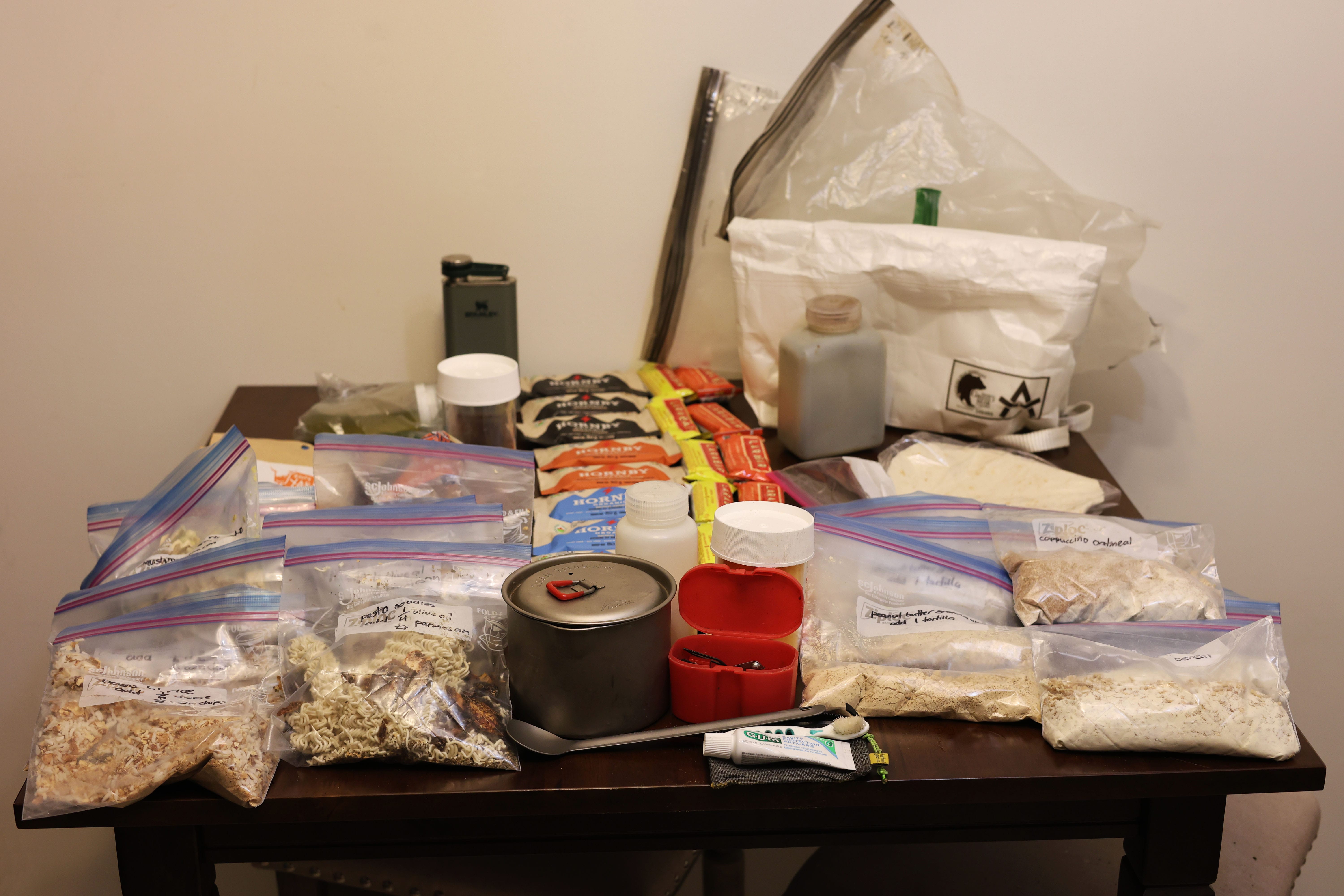
Ten breakfasts, ten dinners, instant coffee, whiskey flask (optional, but pleasant), toothbrush and toothpaste, and at least two snack bars a day, with a third for the two long days. History told me that this should be sufficient, and as expected I got home with a few spare bars. All of this is sorted out into three odor-resistant bags, to help keep the critters from even noticing it, then it all pretty much fits into a single 14-litre ADOTEC Outdoor Gear Ultralight Grizzly Bear Locker. Most sites have some form of bear pole, but not all, and some form of IGBC-certified bearproof food storage is required by Jasper National Park on the North Boundary.
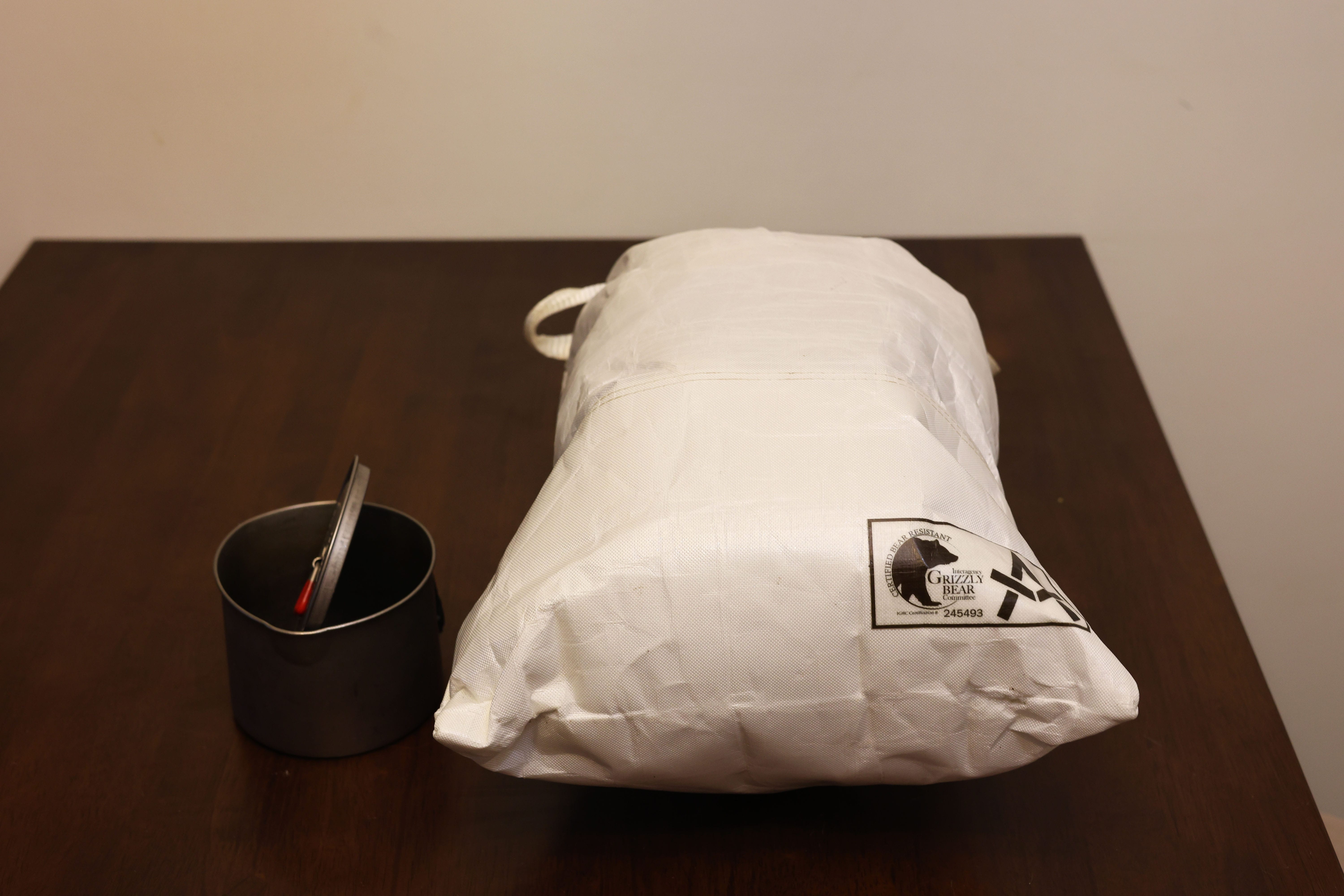
The ADOTEC bag is lighter and more waterproof than the more common Ursack XL, but slightly smaller; however, much more importantly, it is broader, so despite its lower stated capacity I can actually fit more food in it. This is very convenient, since my 50-litre backpack won’t fit two bear bags simultaneously; I did find a practical way to carry an Ursack on a carabiner on the outside shoved into the shock cord on the front of the pack, but I’m much happier not doing that. Carrying ten days of food in one bearproof bag is a killer capability4.
Gear list and outcomes
My backpack is a Superior Wilderness Designs Rugged Long Haul 50. I am very good at buying backpacks, I have never got one I didn’t love, and I love this one more than any other. It wears comfortably, it weighs nothing, it feels rugged enough to inspire confidence, and despite being a lightweight backpack you can load it to the gunwales and still carry it with confidence. My “big backpack” is a 75-litre Gregory Baltoro, which is more than up to the job (I used it on my 14-day Fiddle River/South Boundary Trail trip), but it is a rule of packing that, if one has space, one will use it, and anyway the Baltoro is twice the weight of the Long Haul. I was therefore enthusiastic to get ten days of requirements shoved into 50 litres.
Which I did, though on this trip I carried almost as much in that backpack as I imagine I’d ever like to:
| North Boundary Trail 2025 Gear List | |||
| Item | Description | Quantity | Mass |
| Durston Gear X-Mid Pro 1 | tent | 1 | 1 lbs 0.8 oz |
| Durston Gear Z-Flick | tent pole | 2 | 0 lbs 3.2 oz |
| ZPacks stakes and bag | tent stakes | 1 | 0 lbs 5 oz |
| Therm-a-rest NeoAir NXT RW | sleeping pad | 1 | 1 lbs 3.4 oz |
| Enlightened Equipment Enigma -12 950fp | quilt | 1 | 1 lbs 10.4 oz |
| Sea to Summit Aeros Large Pillow | pillow | 1 | 0 lbs 4 oz |
| Pillow Strap medium red | pillow case | 1 | 0 lbs 2.3 oz |
| Shelter and sleep subtotal | 5 lbs 0.4 oz | ||
| MSR PocketRocket 2 | stove | 1 | 0 lbs 3.7 oz |
| MSR Titan | pot | 1 | 0 lbs 4.5 oz |
| TOAKS long titanium | spoon | 1 | 0 lbs 0.7 oz |
| Bic lighter | lighter | 2 | 0 lbs 0.7 oz |
| LCFUN electric lighter | lighter | 1 | 0 lbs 2.3 oz |
| bear hang kit5 | bear hang kit | 1 | 0 lbs 6.0 oz |
| Stanley flask | camp libations | 1 | 1 lbs 1.3 oz |
| Adotec Bear Locker 14L | bear bag | 1 | 0 lbs 6.7 oz |
| Camp kitchen subtotal | 2 lbs 9.7 oz | ||
| Canon EOS R8 w/ 50mm lens | camera | 1 | 1 lbs 8.2 oz |
| Canon RF 18mm lens | camera lens | 1 | 0 lbs 7.9 oz |
| spare Canon LP-E17 battery | camera battery | 1 | 0 lbs 1.5 oz |
| GoPro HERO 9 | camera | 1 | 0 lbs 5.5 oz |
| Sametop GoPro head mount | camera mount | 1 | 0 lbs 3.0 oz |
| Chicken Tramper camera bag | camera bag | 1 | 0 lbs 7.1 oz |
| Camera gear subtotal | 3 lbs 1.2 oz | ||
| Garmin inReach Mini | satellite messenger | 1 | 0 lbs 4.0 oz |
| Google Nexus 8 | phone | 1 | 0 lbs 9.6 oz |
| Amazon Kindle Paperwhite | e-book reader | 1 | 0 lbs 11.2 oz |
| AfterShoks Trekz Air | headphones | 1 | 0 lbs 1.1 oz |
| Black Diamond Moji+ | camp light | 1 | 0 lbs 2.8 oz |
| PadPal 5.2 | air pump | 1 | 0 lbs 0.4 oz |
| BigBlue 3 | solar panel | 1 | 1 lbs 7.5 oz |
| Anker 20K | battery | 1 | 0 lbs 14.2 oz |
| Anker USB A/C | wall charger | 1 | 0 lbs 4.1 oz |
| charging cables | cables | 1 | 0 lbs 4.4 oz |
| electronics storage bag | fanny pack | 1 | 0 lbs 2.9 oz |
| Other electronics subtotal | 2 lbs 14.1 oz | ||
| Nitecore NU25 UL | headlamp | 1 | 0 lbs 1.7 oz |
| Opinel #8 | knife | 1 | 0 lbs 1.5 oz |
| Fox 40 | whistle | 1 | 0 lbs 0.4 oz |
| first aid and repair kit6 | first aid kit | 1 | 1 lbs 4.7 oz |
| NatGeo Jasper North | map | 1 | 0 lbs 3.4 oz |
| Sea to Summit head net | head net | 1 | 0 lbs 1.0 oz |
| poop kit | necessaries | 1 | 0 lbs 5.0 oz |
| Frontiersman 225g | bear spray and holster | 1 | 0 lbs 11.7 oz |
| Rite-in-the-Rain notebook | trail diary | 1 | 0 lbs 3.6 oz |
| Rite-in-the-Rain pen | pens | 2 | 0 lbs 0.4 oz |
| Helinox Chair One | chair | 1 | 2 lbs 2.2 oz |
| Mayfly Imago sandals | camp shoes | 1 | 0 lbs 2.2 oz |
| Packtowel (medium) | padding, towel | 1 | 0 lbs 3.1 oz |
| Packtowel (small) | padding, washcloth | 1 | 0 lbs 0.7 oz |
| Water bottle holder | water bottle holder | 1 | 0 lbs 2.0 oz |
| Wallet | wallet | 1 | 0 lbs 3.5 oz |
| Keys | keys | 1 | 0 lbs 4.2 oz |
| Parka | friendship | 1 | 0 lbs 4.4 oz |
| Safety and comfort subtotal | 6 lbs 9.0 oz | ||
| MEC AnyWear short-sleeve | shirt | 1 | 0 lbs 5.8 oz |
| Outdoor Research Ferrosi | pants | 1 | 0 lbs 11.7 oz |
| SAXX Quest | boxers | 1 | 0 lbs 3.1 oz |
| Darn Tough Midweight Hiker Boot | socks | 2 | 0 lbs 2.9 oz |
| Wigwam Gobi Liner 2 | socks | 2 | 0 lbs 0.8 oz |
| Enlightened Equipment rain kilt | rain kilt | 1 | 0 lbs 1.8 oz |
| Lightheart Gear rain jacket (2024) | rain jacket | 1 | 0 lbs 7.1 oz |
| Lightheart Gear Men’s Zip Microgrid | hiking fleece | 1 | 0 lbs 12.1 oz |
| Outdoor Research Trail Mix snap pullover | camp fleece | 1 | 0 lbs 13.1 oz |
| Farpointe Drifter | toque | 1 | 0 lbs 0.7 oz |
| Farpointe Alpha Cruiser | sweater | 1 | 0 lbs 3.4 oz |
| MEC Goto T2 | mittens | 1 | 0 lbs 1.2 oz |
| ADOTEC 5L dry bag | clothes bag | 1 | 0 lbs 0.8 oz |
| Spare clothing subtotal | 5 lbs 2.9 oz | ||
| CNOC Vecto 2L | water bag | 2 | 0 lbs 2.9 oz |
| Sawyer Squeeze | water filter | 1 | 0 lbs 3.6 oz |
| SmartWater bottle | water bottle | 2 | 0 lbs 1.4 oz |
| Water and treatment subtotal | 0 lbs 12.1 oz | ||
| Carried base weight subtotal | 26 lbs 1.3 oz | ||
| food bag contents | food, etc. | 13 lbs 0.0 oz | |
| 2L water | water | 4 lbs 6.5 oz | |
| MSR 227g isopro can | fuel | 2 | 0 lbs 13.6 oz |
| Consumables subtotal | 19 lbs 1.8 oz | ||
| Pack contents subtotal | 45 lbs 4.2 oz | ||
| SWD Rugged Long Haul 50 | backpack | 1 | 3 lbs 1.4 oz |
| Carried subtotal | 48 lbs 4.5 oz | ||
| Ultra Adventure hat | sun hat | 1 | 0 lbs 3.1 oz |
| Outdoor Research Echo crewneck | shirt | 1 | 0 lbs 4.3 oz |
| Prana Stretch Zion II | pants | 1 | 0 lbs 14.4 oz |
| SAXX Quest | boxers | 1 | 0 lbs 3.1 oz |
| Smartwool Full Cushion Crew | socks | 1 | 0 lbs 3.0 oz |
| Wigwam Gobi Liner 2 | socks | 1 | 0 lbs 0.8 oz |
| Jim Green Razorback | boots | 1 | 3 lbs 15.6 oz |
| MEC gaiters | gaiters | 1 | 0 lbs 11.7 oz |
| Cascade Mountain Tech carbon fibre/cork | trekking poles | 1 | 1 lbs 0.2 oz |
Many of these items are stored in waterproof bags of some form; those are included in the weights given, and just about all of it was well-proven for long trips. This was my first long trip with a quilt, rather than a sleeping bag, but I’d had it out on overnights and was right to be confident in it, as I was very comfortable. Though keeping weights down for a hundred miles is a good idea, close reading will demonstrate how little I like to compromise on comfort:
-
There is, of course, a chair. A chair is the most unnecessary of camping gear, except for the fact that it’s irreplaceable. I can be slower than some on day one, but by day five I’m keeping up with everyone and part of the reason is that in camp I can truly sit down and relax, rather than propping myself up on a log and being “comfortable enough.” (I use the Chair One rather than the lighter Chair Zero because, candidly, I’m too fat for the Chair Zero; I had one and it was great until I snapped a hub sitting down on it too energetically on the Olympic Peninsula.)
-
I have a full change of clothes. Some of this is hiking prudence: there is no article of clothing which I have not broken at some point on a backpack. I’ve burned holes in shirts and torn seats out of pants. Part of this is courtesy: I boarded the train home having had time for a shower, but not for laundry, and sitting with strangers for 22 hours calls for a certain inoffensive odour. The plan was to hike in the same shirt and pants throughout, doing stream-laundry in camp when able, but with the town clothes fresh. They are all, however, very good hiking clothes, just in case.
-
In the Canadian Rockies I like to wear heavier hiking pants. There’s too much brush-bashing, too great a possibility to slide down something on your butt; they pay. Likewise, fairly serious hiking boots are a great thing to have when you’re not bashing out twenty-mile days every day. I accept that trail runners are best for those who have to do big miles, but my focus is comfort rather than pure speed and with all the fording, mud, and rock of the Canadian Rockies, leather boots are comfortable. Yes, they get wet and stay that way; you’re going to be wet regardless out there.
-
Likewise, washing up in a stream once or twice a trip feels fantastic… or, rather, it feels fantastic after you’ve dried off and stopped shivering. Towels come in handy then and at almost no other time, but I’m also using my towels to pad my spare camera lens when I’m hiking with it, so they are never dead weight.
-
Speaking of cameras… over three pounds of camera equipment may seem excessive when your cell phone takes perfectly good pictures. And that’s because it is. I make no apologies. I hate using cell phone cameras on a rainy hike, because the touchscreen goes mental and you can’t take good photos. A GoPro has enough physical buttons to be better, and the image quality is good enough, but that’s all. So last winter I got a proper camera again, a Canon EOS R8 mirrorless with a couple of basic prime lenses, and the difference in the photos I’ve taken just in places I’ve been to a million times before has been enormous. There is still no replacement for a bunch of glass and a big light-gulping lens, especially in other-than-perfect conditions. Frankly I regret not having such a camera on the South Boundary Trail.
Having learned lessons from the past (when my tent got caught in a flash flood on the West Coast Trail and my old Canon Rebel XS drowned), I also invested in a good-quality Chicken Tramper camera case that I can wear over my chest while hiking so the camera is always both safe and accessible. My spare lens is stored in an attached little DCF bag, waterproofed by a freezer bag and padded by my camp towels; this has worked pretty well so far. I still brought the GoPro, with a head mount, because I had a hankering to video record the Twintree Creek ford, whereupon the GoPro did a GoPro and crashed mid-recording. So that was mostly a waste.
-
Solar charging stands discredited among long-distance backpackers, but long-distance backpackers usually don’t go ten days between power outlets. I also, as you see, go pretty heavy on the electronics when I’m camping, so I like not having to worry about that. If I was more typical and only used a phone with corded headphones for music and photos once in a while, or for anything a week or less, I’d leave the solar panels at home, but that’s not me so I brought them.
-
On average one 227g isopro canister lasts me seven days of steady use, so two was the obvious number to bring. Your experience will dictate the right number here. In fact, not only did I bring more low- or no-cook breakfasts than usual, but I made a couple meals on a campfire so I didn’t even finish off one. I’d still bring two if I did it again.
-
My X-Mid tent is held up by my trekking poles, and the Z-Flicks are spare poles in case I break one (or both!) on the trail. This is a bit more than packing my fears, since I have twice broken a trekking pole while hiking. Once again, didn’t prove necessary but I’d bring them again. They’re the easiest things in the world to pack and for the weight, it’s cheap insurance.
-
I did have to compromise on camp shoes. Mayfly Imago sandals are basically plastic lawn signs for your feet. After a very wet day they are more comfortable than leaving your boots on, and they come in very handy for those nighttime out-of-tent requirements, but otherwise they’re sort of mid compared to a nice cozy pair of hut booties. However, hut booties are bulky and fairly heavy; these sandals are tiny both in volume and mass and somewhat better than nothing. In the event, they were the most infuriating gear of the trip, and I won’t bring them again.
Looking back on this after the trip, the only things I didn’t use were the aforementioned spare can of fuel, the head net (a great thing to not need), sweater, toque, and mittens (it never got cold enough) and some small safety items (the whistle and headlamp). The first aid kit came out, the clothes came in as handy as I thought, everything on that great big list of electronics came in handy except for the GoPro and that wasn’t for lack of trying. Even the Z-Flick poles came out after the end of the hike, when I was set up in a frontcountry campground and they were less trouble than unshipping my trekking poles to get the tent up. So probably I overpacked on warmth, however, it can easily snow in the Canadian Rockies in September, and if it had I certainly wouldn’t have been saying that. Two litres is, for me, about the right water carry in the Canadian Rockies. Really I like to hike between water sources without touching the bottles, but I can’t always, and at my worst I drank not quite two litres out of the bottles before reaching camp.
Where I went heavier it paid off. The Sawyer Squeeze is the largest of the three major Sawyer hiking water filters (the Squeeze, the Mini, and the Micro) but it also has the best flow and is the easiest to backflush in the field; you can do it quite easily with a good bag of clean water and no special gear. Given the fact that more of the water sources were silty than not, a robust filter that can take a bit of clogging before it has trouble is a major asset. I was very glad for my boots when the mud got bad, very glad for a warmer, less-customizable fleece that was relatively clean and highly cozy in camp, very glad for my wide sleeping pad and multi-part pillow setup7 when I had to side-sleep on uneven and erratic pads for all those nights, and naturally very glad for my heavy pants as every day had a fair amount of brush-bashing to be done.
All in all, though I was exorbitantly blessed with my weather, I would consider my preparations well-founded and successful.
- There is a 2021 video of an Astoria Outfitters expedition, but being mostly a series of still images and a horse trip, it is of limited value to the hiker.
- Excuse, therefore, the abundance of posts about this hike. One, it’s the only big hike I’m likely to write about in 2025, so I gotta milk it for all the content I can, and also I’ve done some setup on the site to handle really big, multi-section hikes I’d like to pull off someday. I’m taking the chance to see how well it really works. I promise to do my best to be interesting.
- Great Divide Trail hikers, at any rate, may have the option to register by e-mail; see the GDT website for details. Since I couldn’t get camping anyway, I didn’t look closely into it.
- For comparison, I figure on getting seven to eight days of food into my Ursack XL when using odor-proof sacks: it is larger, but being narrower it is also harder to pack efficiently when the big odor-proof bags are restricting movement. My hard-sided Bearvault BV500 canister, which is the size most people have, will take nine days of food in a relentless no-whiskey no-odor-sacks no-frills pack.
- 2x Black Diamond MiniWire carabiners, 50′ Lawson 2.3mm bear line, 30′ Lawson 2mm glow wire, metal ring, TerrainUL orange DCF throw bag
- Patches, drugs, bandaids, seam sealant, blister prevention and treatment, tweezers, spare cord, spare pen, and a spare pair of glasses.
- Specifically, I had a backpacking pillow, a pillow case which held the pillow on my bag, and I’d then fill the quilt’s stuff sack with all my other stuff sacks and a few pieces of clothes which I’d then stuff under the strapped-down pillow to give me the height for comfortable side-sleeping, without prejudice to being able to layer up in the night.


Hi Ben. I read and enjoyed your detailed and thoughtful post. I and a group are planning to hike the North Boundary Trail this August and your story has helped our planning very much. We have concerns about the Twintree River crossing that we weren’t quite as aware of as we needed to be.
One question I have: how did you measure the distances between camps that you posted in the article? I ask because Parks Canada has an online pdf for the North Boundary trail which contains some contradictory information. Their map shows distances very similar to the ones you posted, with Twintree River roughly 90km from the Rock Creek trailhead. However, the elevation profile in the same document shows Twintree at about 105km. Can you provide any clarity?
Another question, if you’re okay to share. How tall are you and how much do you weigh? I refer to the part of your story where you describe the Twintree River as reaching your mid-thigh. I’m a bit taller and heavier, so mid-thigh means something different for me than it does for smaller members of our group.
Thanks in advance for your reply, Ben.
Hey Jeff,
Thanks for asking. Great questions, too.
1. The distances and elevations I have were GPS measured. The first three days, my GPS was broken and recorded time and elevation but was missing almost all the detail of the track, so I borrowed someone else’s GPS track from a few years ago for the distances while using my own elevation plots. The remaining seven were measured on my Garmin Fēnix 5. They are guaranteed not 100% accurate, especially since you will take at least one route choice that I did not; however, since GPS elevation is so imprecise and device-specific, I decided having distances on my elevation plots that didn’t make sense was the less bad option than having elevations that didn’t make sense full stop.
Parks Canada’s official numbers are even more guaranteed not 100% accurate. Jasper’s trail distances in the backcountry are estimates to begin with and they never, but never update for reroutes.
2. I’m 5’11” and a fat 240lbs. When in August are you planning to go? Obviously a group with some big guys can ford a lot more safely than I did by myself, but I’d push it as late into August as you could get away with if I was you.
Hi and thanks. I’ve certainly found that the Parks Canada trail distances are all over the place. We did the South Boundary in 2022 and those estimated distances were particularly bad. But, as per your note above…what is the route choice you made on the North Boundary that we won’t be making?
We are planning to leave from Rock Creek around August 15, which puts us at Twintree River around August 20. Work commitments make it difficult for us to leave later than that.
Another question about the Twintree crossing: did you do it at the site of the old bridge? We were looking at some online images that show a spot in the river a couple of km downstream that appears to be wider and braided, and possibly a bit more shallow. Not sure if it’s practical to consider investigating that. Time starts to become a factor.
One more question: was there a lot of deadfall on the trail? Lots of stepping over and navigating around downed trees?
Thanks again.
Re: itinerary: mostly little things. You taking a horse trail when I took a hiker trail or vice versa. You skipping Emperor Falls (I mean, don’t do that, but you could). There’s more than one path on the North Boundary, though they don’t separate for long.
When you reach the old bridge site at Twintree Creek there’s a blazed trail by an old “no camping” sign that parks has cut to a new ford further downstream. Possibly that’s what you’ve seen online. Do not ford at the bridge; it’s narrow there and that would be horrific.
I ran into the Parks Canada trail crew coming from Berg Lake on Snake Indian Pass, so there was no deadfall on the second half of the trail because the crew had been through literally a couple days before. Prior to that, there’d been some deadfall, but nothing worth getting worked up over. Pretty standard.
Hi Ben. Our planning continues and we have booked to leave Rock Lake on August 16. Would have gone later if we could, but there you have it. Questions: where you crossed Twintree, do you recall if there were trees or anything big enough to securely tie ropes to? Also, could you guess at the distance across? We think it’s about 20 metres.Thank you.
My friend and I are also planning to hike the NBT in Aug 2026.
From the videos I’ve seen the one consistent thing is that the distances are all over the place.
No 2 sources show the same distances for some reason. I would trust the GPS based ones more than the ones from Parks Canada.
Thanks Derrick. I’m sure you’re right about that! When are you planning to leave? Perhaps we’ll meet on the trail.
Our plan is to leave Rock lake on Aug 15, so we might be just a day ahead of you.
We also plan to take a 0 day at Twin Tree to get some rest and do some fishing which put us at the same place at the same time.
We’ll have plenty of time to scout the twin tree crossing but there could be some benefit with doing the crossing in a bigger group together.
Hi Jeff, we are planning on starting Aug 15.
There is a planned zero day at Twintree for some RnR and fishing.
If we are 1 day ahead you should catch us there.