


Ben Massey. Backpacking enthusiast, creator of this site, former writer of sports articles for several websites and one magazine, all-round handsome guy, and writer of his own blurbs.
In August 2023 I hiked quite a lot of Banff National Park’s Sawback Trail. It was a good time, mostly, but the weather was depressing, I lost my ebook reader, I broke my phone, and ahead of what would have been by far the toughest day of the trip there had been twelve hours of rain and I hadn’t slept a wink. So I hiked out of Johnston Canyon and went home. The details are in that diary if you want to read about the angst (a fair bit) and drama (not much); the point was I had left the job un-done.
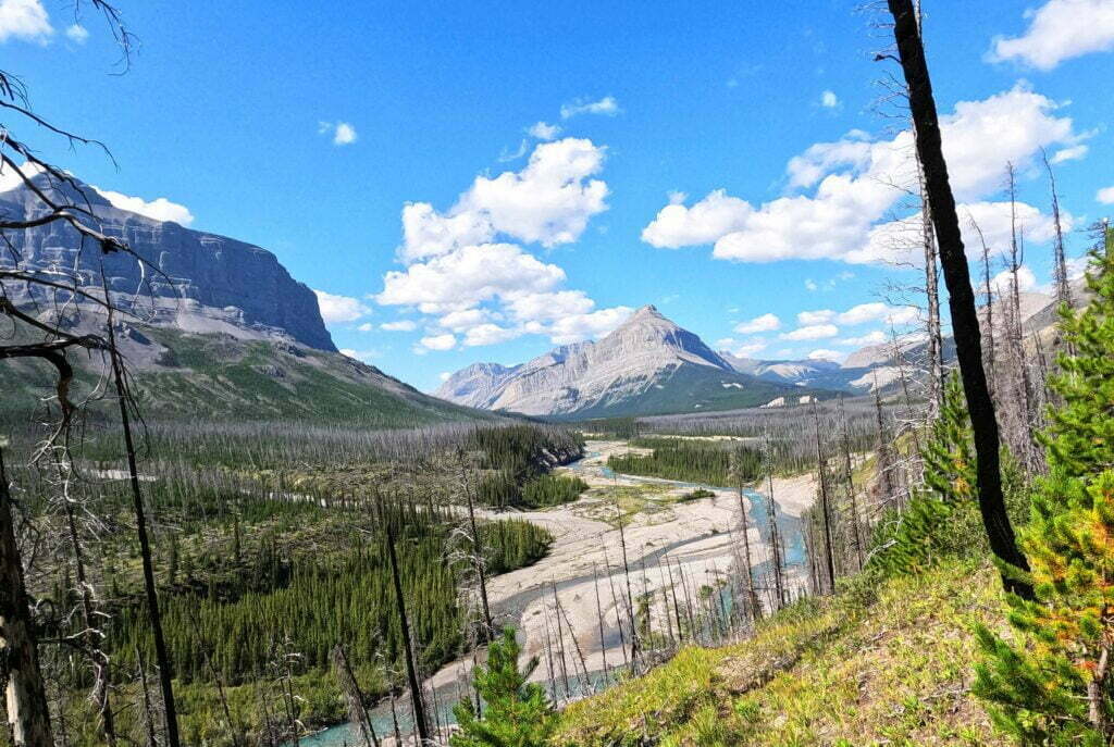
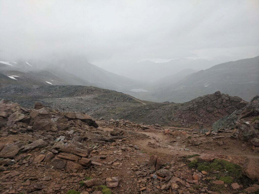
So I booked a early-mid-July hike from Banff to Lake Louise, with a twist: rather than retrace my steps up the Sawback Trail, I would take the back half of the Sawback Loop, past Block Mountain and over Badger Pass. It was a fun idea. but ne’er yet has mortal man come up with the perfect plan and this wasn’t the exception. I was hiking somewhat early in the season, and according to the Canadian Rockies Trail Guide Badger Pass measures up at 2,565 meters (8,415 feet), “one of the highest trail-accessible passes in the Rockies [. . .] about as wild and remote a place as you could imagine,” featuring rocky, easy-to-lose trail, cornices, boulders, steepness, and Type 2 fun.
Badger Pass in early July would have been fine for the past several years, but not 2024. There was a cold spring and a late melt. No backcountry updates from Banff covered the area, and many lower points that had been updated were “not recommended” due to snow and even avalanche risk. What to do?
What to do was, once again, not go to Lake Louise. I would call it another frustrating failure, but this time it was entirely on my own terms. The trip I wound up with was the simplest out-and-back you could imagine, and one of the best times; accessible, given enough days for comfort, to many a hiker.
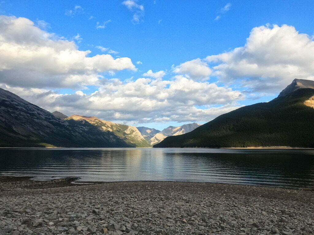
Mount Norquay to Block Lakes Junction and back, 50 miles almost on the pin. You know what? Recommended.
Never miss a ramble
Ben will hike to your inbox! New posts and nothing else.

Everyone knew it was going to happen. The town of Jasper is… was? in a forest of trees killed by the mountain pine beetle, Dendroctonus ponderosae, over recent decades. Dry, hot summers, prone to lightning at all times of year, and filled with tinder. Now it sounds like the town is burned to the ground. Inevitable, but no less sad for it.
Naturally, blame is being cast. It’s the provincial government’s fault. It’s the federal government’s fault. It’s Parks Canada’s fault. The simple fact is that forest fires happen there, always have, massive ones, and when civilization came and started putting them out it did not eliminate the conditions but let them accumulate until they were past human control. Alberta, and Canada, are a long way from the only places to see this happen.
Vanity of vanities, says the Preacher,
vanity of vanities! All is vanity.
What does man gain by all the toil
at which he toils under the sun?
A generation goes, and a generation comes,
but the earth remains forever.
They say if you never bail out on a hike you’ll eventually regret it, but they don’t say that when you do you’ll regret it anyway.
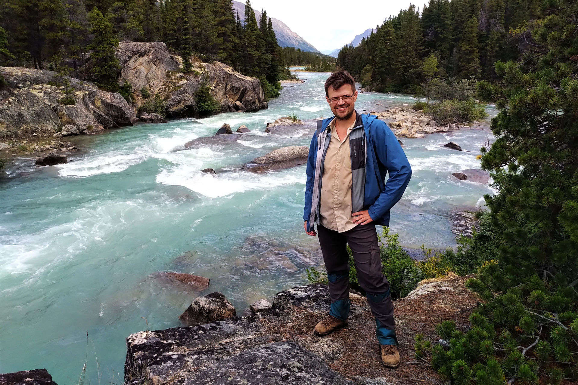
Even when I sprained my ankle hiking to Norvan Falls a few years ago, I finished going to Norvan Falls (though when it happened I was almost there anyway). But after four days of lousy weather, failed gear, and a sleepless night before a steep and dangerous-seeming day far from help having just seen somebody else hurt himself, my nerve failed me and I went home early. As a result this is not the full Sawback Trail, from Banff to Lake Louise; just a lot of it.
One can’t A-B test these things. No Control Ben pushed on to either hurt himself or be fine, so I shall always wonder. Writing up my diary for the trip I found I was justifying the decision to myself. The humble reader is welcome to judge, and I am actually interested in your judgement if you do, but the Inner Adventurer forever remains unsettled.
It was a real hike. Four days towards my goal before finishing up at Badger Pass Junction and returning. 43 miles, mostly short days, and a great deal of spectacular country. The Sawback Trail is recommended, but my luck was out: every day it rained hard. I lost my Kindle and broke my phone, which meant that I had heck-all to do while pinned in my tent.
I’ve been rained on in the Rockies plenty, but I’d never had a trip where it was just always raining; apart from the electronics problems I managed well, and that was good too. Failure can be as interesting as success. Right?
An easy out-and-back hike beside an artificially-dammed lake. Lake Minnewanka in Banff National Park is very popular, but not a glamorous spot for the hardcore hiker.
Most backpackers like a little struggle to give them that sense of achievement when they eat a freezedried meal and hide out the storms in their little nylon shanty. All else being equal they’d rather be alone, and out-and-back hikes are a chore. Since there’s no trail around the south side, Lake Minnewanka is popular, easy, and an out-and-back by definition unless you shoot the Devil’s Gap and come out pretty far from anywhere, near the South Ghost Recreation Area. Plus, though it’s an ideal shoulder-season hike, the Minnewanka trail is restricted to groups of four or more most of the summer to mitigate against the many, many, maaannnyyyy bears that congregate in the abundant and convenient berry bushes to get their feed on. So it’s a logistical hassle too!
I went because I was curious and because, since I had a few days at the beginning of July, it seemed like a good one to check off the list. I’d planned to do the whole thing, out and back, as far as the Ghost Lakes, but I didn’t. Too bored. So there’s an anti-recommendation.
However, dull though the hiking is, the camping is lovely. The easy trail, too, makes this probably the single best beginner’s backpack I’ve ever seen. Curious about this Rocky Mountain lark but understandably reluctant to brave bears and lightning when you don’t really know what you’re doing? Come to Lake Minnewanka! It’s so, so easy to get to, it’s as easy as hiking gets, and it’s rewarding! The hike is anything but a waste of time, especially when you’re in camp, sitting on the beach with your food and your book, watching the sun play across that vast lake. Want to bring the kids? They’ll have places to play and splash around, and the days can be almost as short as you want them to be.
The South Boundary Trail. To some those words are instantly evocative. They mean history, grandeur, self-reliance, and solitude.
Jasper National Park has beautiful backcountry, from Skyline to the Brazeau to the Tonquin Valley; the South Boundary’s isn’t the same. The scenic highlight is Nigel Pass, which is also a day hike and easily backpacked on the Brazeau. Otherwise, there are wonderful moments but not constant stimulation. No 3,000-foot climbs, no camps above treeline.
The South Boundary just feels different. The ninth Earl of Southesk put it on the map in 1859 when, recovering from injury, illness, and the loss of his wife, the 32-year-old peer explored the Front Ranges, defined a great Rocky Mountain backcountry trek, met legends of the Canadian West, read Shakespeare and Bulwer-Lytton, and wrote his account with a personality that any fan of obscure backcountry content will recognize. The hunters with him had hardly the vaguest idea where to go: they were experts, not guides, and the earl pioneered this route.
As Jasper matured the South Boundary became popular until, around 1994, the parks began their long retreat from the backcountry. Wildfires in 2003 and 2006, and a flood in 2013, decimated the trail, and little was repaired. Reports discussed how difficult the path could be to find, let alone hike.
Then, in 2019 Stuart and Evelyn Howe recorded a two-and-a-half hour video of their hike. They found Rocky Pass, navigated the washouts, made it to the old paths above the Southesk burn, then got down to the bridge. They showed what victory looked like, posted their GPS tracks, and more would-be hikers were inspired to follow them. In the years since the trail’s been better-marked by cairns, markers, and flagging, and the park has made a couple maintenance trips. One hesitates to call a 75-mile trail with chancy fords, multi-mile route-finding, primitive campsites, unbrushed trails with six-foot willows, and one thoroughly remote trailhead “easy.” But it mostly is.
Hiking Jasper’s Fiddle River trail in mid-August had a simple object: to reach the South Boundary Trail without a three-hour taxi ride.
Living a long way from the Rocky Mountains, I get at most one hike out there a year and the Fiddle River would never make the cut. However, it suited my South Boundary goals perfectly: take a taxi to Miette Hot Springs, hike for three days, cross Fiddle Pass and emerge on the Grave Flats Road less than eleven miles from the Rocky Pass trailhead. It made for 14 days on the trail and about 111 miles (179km) of hiking, with a garbage bin en route but no resupply.
Thus the Fiddle River was not really a “trail” to me: it was an approach. Every niggling inconvenience—and there were a few—wasn’t part of my adventure, but part of my commute. I didn’t realize what a difference that would make mentally until I was at Medicine Tent campground four days later and magically felt better. Carrying a pack with two weeks of food and fuel didn’t improve my mood.
For all the frustration the trail did create some fond memories. Fiddle Pass is lovely, the rivers and creeks are distinct pleasures, and if you want backcountry nights that are private and rugged but not too “out there” I suggest Utopia and Slide Creek campgrounds. It’s just thru-hiking it with a big pack was the wrong way to go, when you could experience the parts you’d like on a less frustrating out-and-back. When you tie the whole trail together, trying to get from one end to the other, Fiddle River is a hassle.
This trip was a single 14-day hike to me, but as it covered two trails at Jasper National Park, joined by a half-road-walk half-hitchhike, I’m dividing it into two posts for readability.
This time of year, people talk about their backpacking plans. The luckiest souls plan to be out most of July and August, and I cope and seethe for like most of us, I get at best one good backpack a year. So naturally I plan it out to avoid being hosed by the booking gods, running down my list of must-do hikes every January and finishing on one can-do for August that’s as fun as I can make it. Moreover, this year I felt a hankering to get as close to the all-summer hiking crowd as I could, to make my one trip a real marathon.
My Western Canada backpacking bucket list goes something like:
So it’s the South Boundary for me in 2022, because I want to do the North Boundary and can’t.
Jasper National Park’s North Boundary Trail is a dream hike. From Celestine Lake to the Berg Lake trailhead in Mount Robson Provincial Park, it is much-discussed but not often-hiked. This year Thompson Valley Charters started a bus between Kamloops and Edmonton stopping at Mount Robson. I would have made it if not for Heat Dome, whose melt flooded these trails. BC Parks closed the Berg Lake Trail beyond kilometre 7 in August.
Also closed was a bridge over Twintree Creek, one of the few remaining on the North Boundary. Stuart Howe’s 2019 video shows horrible rushing blue-white water and Parks Canada has officially closed that bridge on pain of a $25,000 fine.
Berg Lake is closed for 2022 while under repair, but the North Boundary is long-neglected. Reservations are refused until September because Blue Creek bridge washed out in 2014 and they want hikers to wait until water levels go down. By all accounts Twintree Creek is tougher; it’s probably safest to consider the trail closed.
Would Jasper National Park lose a marquee trail for want of a bridge? Well, it keeps happening. The Fortress Lake trail into Hamber Provincial Park has been cut off since 2014 because of a washed-out bridge over the Athabasca River. The Athabasca Pass trail, leading to a National Historic Site of Canada, has been nigh-unreachable since the winter of 2016 due to a lost bridge at Simon Creek.
This is normally when an author bemoans Parks Canada’s budget and suggests the reader somehow vote our way out of it. Yes, Parks Canada should have the money far more than other things all politicians treat as higher priorities, but they ain’t quite broke. Earlier this year they built a 113-metre suspension bridge above Logan Creek on the West Coast Trail. A safe existing route has received a spectacular upgrade that will save hikers from what was once a morass of ladders and a shorter, still-memorable suspension bridge. The contract was valued at $840,122.
Bridges can be built, when they’re a priority.
After two years of frustrated would-be backpacks in the Rocky Mountains1 2020 would be a winner. A half-dozen early mornings, scoring opening-day reservations for some of Canada’s most-coveted campsites. Jasper frontcountry, Banff frontcountry, Jasper backcountry, Banff backcountry, provincial parks: processing and stress, HTTP 503s and duplicate credit card charges: all worth it to see great trails in peak season.
Take the train to Jasper, one night in the frontcountry, then two on the famous Skyline Trail. Bus to Banff, and three more nights up the Sunshine Village gondola, through the Assiniboine Pass, and down to the southeastern corner of Banff National Park via legendary Lake Magog. A trip worth the wait.
Then the virus came. VIA Rail, Canada’s passenger rail provider, suspended transcontinental service for the year. So I had to fly into Edmonton, with associated problems moving fuel and bear spray, and bus to Jasper on Sundog. This meant a needless night at Wapiti, watching elk and ordering pizza.
On the Banff side Sunshine Village announced they, including the gondola leading to Assiniboine Pass, would not open for the summer of 2020. So an already-long day would be lengthened by a sketchy cab ride and a boring uphill walk. Then, in July, the bombshell: a nice lady from Brewster called and said that due to “extreme low demand” their Jasper–Banff bus would not run until September at the earliest2.
It was disappointing but one cannot be angry at small businesses trying to survive in a time of panic. Every thwarted booking, every reservation canceled, was refunded promptly and without hassle. Everybody was very polite, and the reputation of the Rocky Mountains’ little transport companies and outfitters has only improved. But now I could either go to Banff and do Assiniboine Pass, or go to Jasper and do Skyline, but, with no connection between them, not both.
I chose Skyline. A mistake was made.
Unless otherwise noted, all content copyright 2016—2025 Benjamin Massey. All rights reserved. Any icons or trademarks used are the sole property of their respective companies. Powered by Wordpress.
3